Houston is learning, to its dismay, that government officials and politicians knew decades ago that two vast reservoirs built 70 years ago by the U.S. Army Corps of Engineers would have to be spilled open one day and that, when that happened, people would die and property would be destroyed.
Houston also is learning why that truth wasn’t trumpeted loud enough for all to hear. The answer is that Houston, bent on growth and money, didn’t want to hear the trumpet.
We’re in the same bad boat. Not only are we ignoring the same magnitude of risk in our metropolitan area, but we even are engaging in a supreme denial of reality by proposing to build a fancy new park for hundreds of millions of dollars in the Trinity River floodway.
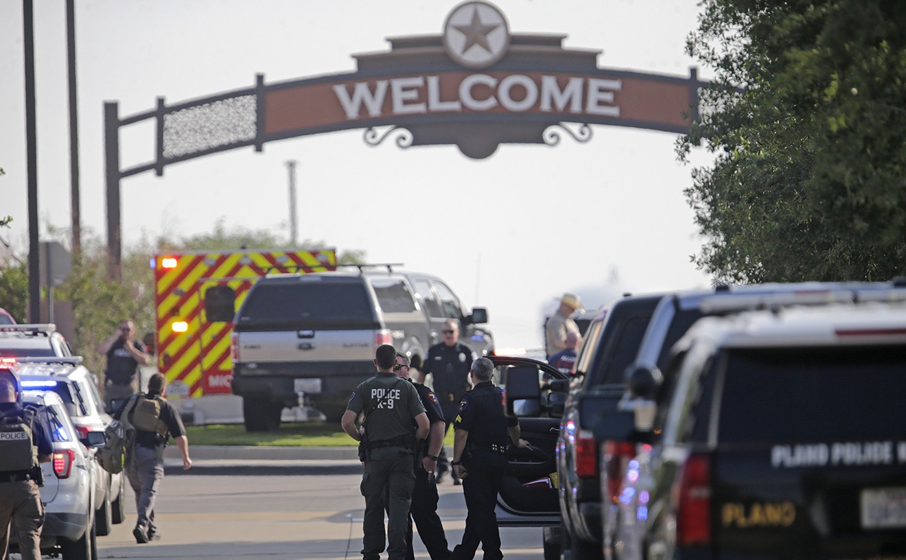
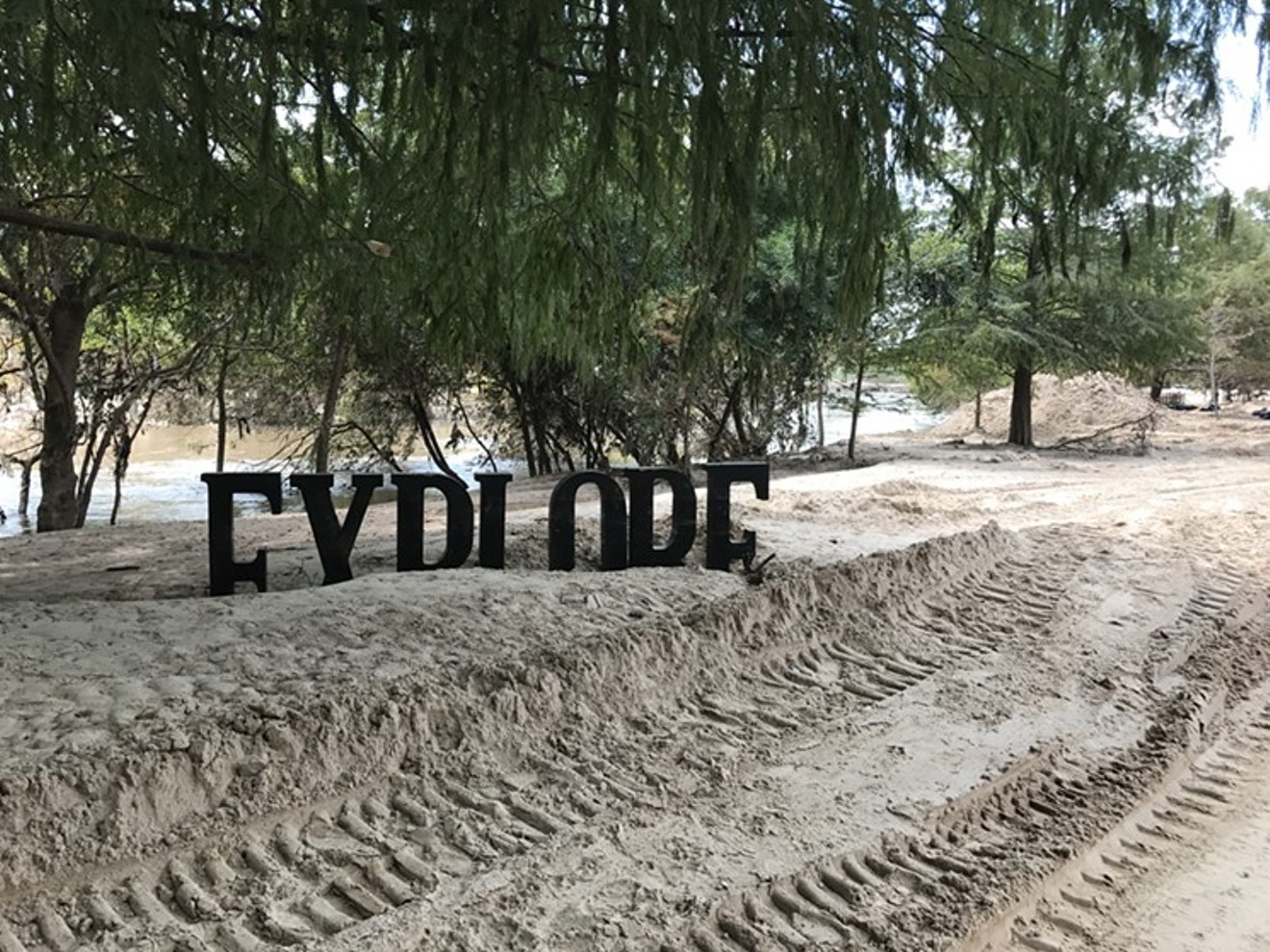
About three weeks ago in the Houston Press, Dianna Wray wrote a great piece about what happened to Houston’s fancy Central-Park-wannabe park along the Buffalo Bayou after the U.S. Army Corps of Engineers opened floodgates at the Addicks and Barker reservoirs during the rains associated with Harvey. The photograph you see at the top of this piece tells the whole story.
A few people in Houston are referring to the gray matter piled on the ground at the park as sand, some even calling it beachlike — which, as their noses must surely tell them, is an exercise in extreme euphemism and denial. The foul-smelling material you see piled on the ground in Buffalo Bayou Park is a noxious batter of silt, sewage and solid waste.
As Wray reports, Buffalo Bayou Park has been inundated three times in two years: in Houston’s Memorial Day and Tax Day floods and by Harvey. This time, the damage was so severe that people in Houston are rethinking the whole idea of a fancy park in a floodway. Here in Dallas, we’re just getting ready to build a new one.
It’s not as if we don’t have choices. All this year, Dallas landscape architect Kevin Sloan has been urging people to rethink the park the mayor wants to build along the Trinity River downtown.
tweet this
It’s not as if we don’t have choices. All this year, Dallas landscape architect Kevin Sloan has been urging people to rethink the park the mayor wants to build along the Trinity River downtown. And it’s not that Sloan is anti-park. He likes fancy parks, as long as they are in fancy places.
But he wants people to realize that rivers in Texas had to deal with cycles of severe drought and violent inundation even before vast cities were built along their banks. They are built for it. What they are not built for is elaborate manmade structure and landscaping.
At a seminar in March, Sloan told a large audience that any new park along the Trinity River “must acknowledge these demands and be forgiving of the deluge and drought cycles. The one landscape that can do that is the original landscape.”
Our opportunity is to look with horror and deep commiseration on what the rains of Harvey did to Buffalo Bayou and then go another way here, allowing nature to design our park. A natural preserve, as Sloan has urged, is the only design that that will spare us the worst of Houston’s fate.
Our region, variously called “Tornado Alley” and “Flash Flood Alley” by meteorologists, also is subject to violent inundation. A slick, grassy, open floodway full of migrating birds and bobcats would be a more unique urban treasure, anyway, than yet another manmade fantasy version of nature.
In an even more profound and consequential sense, the issue of the kind of park we build along the river is a marker for the much larger responsibility we have to protect life and limb.
In Houston, the real estate lobby went to war years ago to prevent the Corps of Engineers or anyone else from talking too publicly about a key concept called the inundation zone. Every big reservoir sits above a dam, and below every dam is a zone that will be inundated if that dam is either breached by a failure or deliberately opened to prevent a breach.
It’s not a mystery. There were precise maps of the inundation zones for the Houston reservoirs, accurate to within a matter of yards, showing not only where property would be destroyed but also where people would die in the event of an inundation. Those maps also exist for the dams upriver from downtown Dallas.
Some years ago, I was able to look at a detailed inundation zone map for the Lake Lewisville dam. I regret deeply that I didn’t keep a copy somewhere. Now the maps are harder to get. But when I took an image of the inundation zone map for the Lewisville dam and overlaid it with a Google Maps image of what was on the ground some years ago, I saw that our inundation zone, like Houston’s, was covered with subdivisions added since the dams were built. Like Houston, we have tens of thousands of families living in houses that would be directly in the path of floodwaters from a major dam breach.

This PowerPoint slide from a presentation by the U.S. Army Corps of Engineers has been modified to show the location of downtown Dallas.
USACE
Like Houston, we could have known. We could have elected public officials who would have been tough on the real estate whores when they wanted to hide the truth from homebuyers. Of course, that would have amounted to a kind of regulation, and regulation, as we know, raises prices. We wanted what we wanted — cheap, big houses right now. In a nation that affords us more democratic control over our destinies than almost any other on the planet, we get what we vote for.
Although the feds now are using some kind of Homeland Security hocus-pocus to hide the inundation zone maps, the concept is still out there, and the concept is really just too damn big to hide. A minimal amount of poking around will give us a pretty good idea where the inundation zone lies for Lewisville dam.
I am showing you two illustrations here that I cut out of PowerPoint presentations put together by the Corps of Engineers within the last two years. I have modified one by adding a red star to show where downtown Dallas is. The second one is made up of two sections of a larger slide that I cut out and put next to each other.
The first illustration is a map of the river from Lake Lewisville to a point south and downriver of Dallas. The blue zone around the river, extending out for miles from the river’s banks in some areas, is what will flood if the dam breaches or is opened to prevent a breach. Much of that blue area is densely developed.
The second illustration is even more chilling because it shows “population at risk,” apparently during a daytime breach. It’s crude, as illustrations go, because it doesn’t provide a precise scale of area. But it gets the idea across. The blood-red dots depict places where “20 and above” lives would be at risk in a breach.

Red dots are areas where 20 or more lives would be at risk in the event of a daytime dam breach at Lake Lewisville.
USACE
And here’s the worst part: We elected them. The other kind of politicians are out there — the ones who get all of this, who believe in telling people the truth and who want to take communities out of harm’s way instead of putting them directly in its path. Some even are in office already, from city councils to the Legislature. I’m not so sure about the Congress, and we will not speak of the White House, OK? It’s just too long a day already without that.
But here we are, with the terrible specter of Houston right in our faces. We can see exactly what happened there, what did not happen and why. All the same risk factors are in place in our part of Texas. We know what we would have to do to protect ourselves from the same fate, whom we’d need to vote out and whom to vote in.
And what are we doing instead? We are getting ready to build a fancy, rich-lady, Central-Park-esque park in the floodway in the center of our city. We are fiddling, in fact, while Rome drowns.