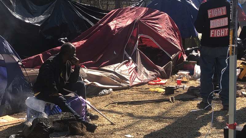

If you’ve ever wondered how many homeless encampments there are across Dallas, an Austin-based tech company has an estimate: at least 230, not counting the downtown area.
On the front page of the Nomadik AI app, red outlines on a satellite map of Dallas indicate where the company believes an encampment to be. But in the week it took to build the map, co-founders Trevor Sorrells and Morgan Winters never actually stepped foot in Big D. Instead, they relied on a combination of first-person reporting and public records analyzed by artificial intelligence to determine where the encampments exist.
“It's not the spooky AI that everyone kind of associates AI with, like Silicon Valley tech bros, and more trying to look for patterns in the environment,” Sorrells told the Observer.
Sorrells and Winters moved to Austin three years ago to work for a defense startup, tracking maritime intelligence for the Navy. After two and a half years, they wanted to use those skills to do some good on the domestic side of things: they tossed around tackling the opioid crisis, housing, poverty and crime, but settled on homelessness because it’s the area where “all of those issues coalesce.”
Starting in Austin, they developed an AI system that scans through various data sources like social media posts, news articles and police reports to identify patterns — such as recurring police reports of opioid possession in the same area — that indicate a likely encampment is nearby.
Then, they went out into the city to confirm what the data suggested. More often than not, it was correct.
“In Austin we have a lot of really dense green belts right downtown, so you can basically just disappear into them,” Sorrells said. “Our outreach team is in the camps six or seven days a week, going around just talking to people, providing normal outreach stuff: water, food, blankets … And a lot of the time, we'll go into a camp and they're like, ‘The city's never been here.’ The camp's been there for three years or something, and no one knew it was there in the first place.”
Which is a problem, Sorrells said, especially for first responders. In March, a fire started at a homeless encampment in Austin’s Barton Springs Greenbelt, leading firefighters “deep into the woods” to provide assistance, AFD said. Nomadik AI’s data could have been useful in that instance, as well as during the greenbelt fires last summer, which were caused by the dry conditions. The app already allows users to add inventory information such as population, pets, propane, gas and debris levels to known encampments, and that data could be used by police, EMS personnel and firefighters when preparing to respond to an emergency.
The app can also be used by homeless individuals, Sorrells added. On Austin's map, resources such as food banks and shelters are marked with large blue and green bubbles. On a separate tab, a short questionnaire helps point a user to their nearest resource depending on their needs.AFD on scene of a large fire in the woods behind the 4200 block of S Lamar Blvd Svrd. Crews deep in the woods fighting fire. Avoid the area #ATXTraffic pic.twitter.com/BOphaxSNom
— Austin Fire Info (@AustinFireInfo) March 2, 2024
“A lot of this information is extremely siloed, so you'll have the nonprofits who have a lot of specific information, the Austin Police Department will have a lot of specific information, the fire department, the city, same thing. And none of them seem to be talking,” Sorrells said. “So we wanted to be able to kind of centralize that information and coordinate them a lot better.”
Moving in to Dallas
Mapping Dallas’ encampments has been the company’s first attempt to expand beyond Austin, and Dallas was selected due to its proximity and open data collection that is similar to the capital city’s.
On X, Council Member Cara Mendelsohn commended the early draft of Dallas’ map, saying it was “remarkable.” Mendelsohn, who is the vice chair of the city’s Housing and Homelessness Solutions committee, has been outspoken about the need for more strict enforcement of laws that outlaw encampments. She has documented her own attempts to reach out to individuals living in encampments in her district on social media, saying they often decline assistance when offered.
“There are four homeless encampments in District 12's Rosemeade Park right now and they are setting fires nightly, harassing customers at nearby businesses, leaving litter throughout the park and surrounding areas, and loitering at nearby churches and businesses,” Mendelsohn told the Observer.
She started following Nomadik AI’s tracking efforts in Austin, and hopes to use the data to encourage first responders to be “more proactive” when responding to District 12 encampments. The information could also help businesses strengthen security and alert the park department to needs for litter removal and encampment clearing, she said.
Nomadik isn’t the only page Mendelsohn is taking out of Austin’s book. She has voiced support for a Dallas-sanctioned homeless encampment similar to Austin’s Esperanza shelter, which provides security, bathrooms and showers, support services and tent camping areas for homeless individuals. A sanctioned encampment would be an “additional choice that could be offered” as encampments are closed, she said.
At Trinity Mills @ tollway, I spoke to a young man and young woman under this pink blanket. There are at least 1-2 other people under the tarps. They are totally drugged out. Don't want to go to a shelter. Say they don't have IDs. I told them I could help them get an ID and a… pic.twitter.com/IaC7S0kBvC
— Cara Mendelsohn 🟦 (@caraathome) July 6, 2024
“House Bill 1925 outlaws camping on public land. We should enforce the law. That cities in California are clearing encampments but Dallas isn't is notable,” Mendelsohn said. “I believe in a compassion-plus-enforcement approach. Dallas has done a great job on compassion, but no enforcement. I believe this must change.”
Although Nomadik’s website mentions municipal partnership opportunities, the Dallas map was made without an official relationship with the city, Sorrells said. Council Member Jesse Moreno, Chair of the Housing and Homelessness Solutions Committee, declined to comment when asked how the committee could best take advantage of the encampment data.
It's been only about half a year since Nomadik AI began tracking encampments in Texas, but the progress is promising, Sorrells said. They plan to expand to more cities, such as Houston, as their system is perfected.
"We're not going to solve homelessness, right? We're two guys who work in a house," Sorrells said. "But we can provide a solution that at least enables everyone else who is doing the groundwork to have a leg up in terms of trying to solve the issue, and trying to better characterize it. Because we're in the camps every day, and every single person has a different story, and a different reason they're homeless."